2023-2024 USAP Field Season
Project Detail Project TitleUS Antarctic Marine Living Resources Program (AMLR) Summary
Event Number:
Program Director:
ASC POC/Implementer: Principal Investigator(s)
Dr. George Watters
Project Web Site: Location
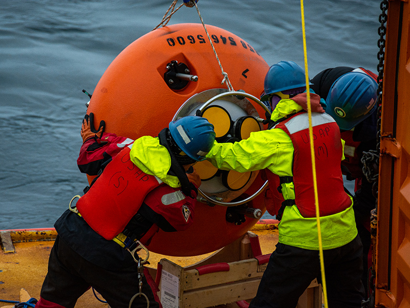
Supporting Stations: ARSV Laurence M. Gould DescriptionThe National Oceanic and Atmospheric Administration (NOAA) Fisheries' Antarctic Marine Living Resources (AMLR) program collects data and provides scientific information to better inform decision making by the Commission for the Conservation of Antarctic Living Marine Resources. For the past 25 austral summers, the AMLR field program has been conducted in the vicinity of Elephant Island, the South Shetland Islands, and the Antarctic Peninsula. The Antarctic Ecosystem Research Division (AERD, Southwest Fisheries Science Center) will deploy an array of upward-looking acoustic moorings and a fleet of autonomous gliders, equipped with acoustic sensors to collect data on biomass distribution and transport of krill. The objectives of this work are: 1) to quantify and understand interactions between krill, krill predators (e.g., penguins and seals), and the Antarctic krill fishery; 2) to estimate krill flux through and standing biomass in areas where krill, predators, and the fishery overlap in space and time. The deployment of moorings and gliders off Cape Shirreff, Livingston Island continues a time series established in 2018, while the moorings and gliders deployed in Bransfield and Gerlache Straits will provide data on biomass of krill in the Bransfield Strait.
Field Season OverviewThe NOAA-AMLR group will recover eight subsurface moorings deployed in December 2022 and deploy up to four Slocum gliders while aboard the ARSV Laurence M. Gould (LMG). The gliders will be recovered around February 2024 by Palmer LTER as part of an ongoing project supported by USAP. Mooring recovery sites are located north of Livingston Island on the continental shelf and at the mouth of the Gerlache Strait. Subsurface floats are connected to a terminal top-side assembly which is outfitted with an acoustic package consisting of an upward-facing sonar, a conductivity temperature depth (CTD), and an acoustic Doppler current profiler (ADCP). The gliders have been outfitted with a suite of acoustic sensors that will collect data on krill density. Experimental use of new sensors nicknamed “glidercams” will take pictures of microfauna in the water as the gliders dive. Deployment and recovery sites of the gliders will be dependent on weather and sea conditions. Operations will be coordinated with NOAA glider pilots, Antarctic Support Contract (ASC), Marine Projects Coordinator, and the vessel’s Master. The gliders will collect data for approximately 60 days; final coordinates will be agreed upon in the days leading up to deployment and recovery. Deploying Team Members
|
2023-2024 Science Planning Summary

For USAP Participants |
For The Public |
For Researchers and EducatorsContact UsNational Science FoundationOffice of Polar Programs Geosciences Directorate 2415 Eisenhower Avenue, Suite W7100 Alexandria, VA 22314 Sign up for the NSF Office of Polar Programs newsletter and events. Feedback Form |

: Livingston Island, Gerlache Strait")
