|
OPP-funded Researchers Create the Most Accurate Antarctic Map Ever 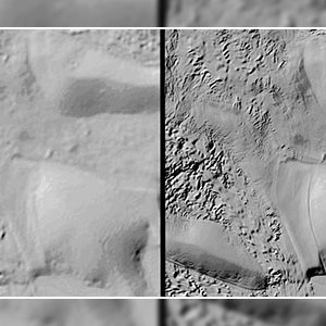
National Science Foundation Posted September 5, 2018 NSF funded researchers at Ohio State University using NSF funded supercomputers at the University of Illinois at Urbana-Champaign have produced the most detailed map of the Southernmost Continent ever created. The National Geospatial-Intelligence Agency, in partnership with NSF, also provided support to the project. A viewer is also now publicly available that that allows users to customize and download maps of their own. The new map, called The Reference Elevation Model of Antarctica (REMA) / https://www.pgc.umn.edu/data/rema/), has a resolution of between 2 and 8 meters, compared to the 1,000 meters that was typical of previous maps. “Up until now, we’ve had a better map of Mars than we’ve had of Antarctica. Now it is the best-mapped continent,” said Ian Howat, professor of earth sciences and director of the Byrd Polar and Climate Research Center at The Ohio State University, who led the mapping project. The map will benefit science because it is precise and accurate enough that it will allow #research teams to plan some trips over the continent's treacherous terrain without the risk or expense of having to deploy into the field, he added. Collaborators on the project include the NSF funded Polar Geospatial Center at the University of Minnesota. The University of Illinois at Urbana Champaign provided access to the Blue Waters supercomputer that processed the images. Esri, also a partner in the REMA development, has created an online web mapping application to allows users to explore the REMA data. The REMA Hillshade Viewer allows maps to be exported, distances to be measured and images to be exported. The shaded relief is optimized to enhance the texture of the ice. Users can also can zoom to a location and create a map link to send to friends and colleagues: https://www.maps.arcgis.com/apps/shared/origin/index.html?appUrl=https://www.arcgis.com/apps/View/index.html?appid=86a9728459aa4d18b4444b74d330832e
|

For USAP Participants |
For The Public |
For Researchers and EducatorsContact UsU.S. National Science FoundationOffice of Polar Programs Geosciences Directorate 2415 Eisenhower Avenue, Suite W7100 Alexandria, VA 22314 Sign up for the NSF Office of Polar Programs newsletter and events. Feedback Form |
